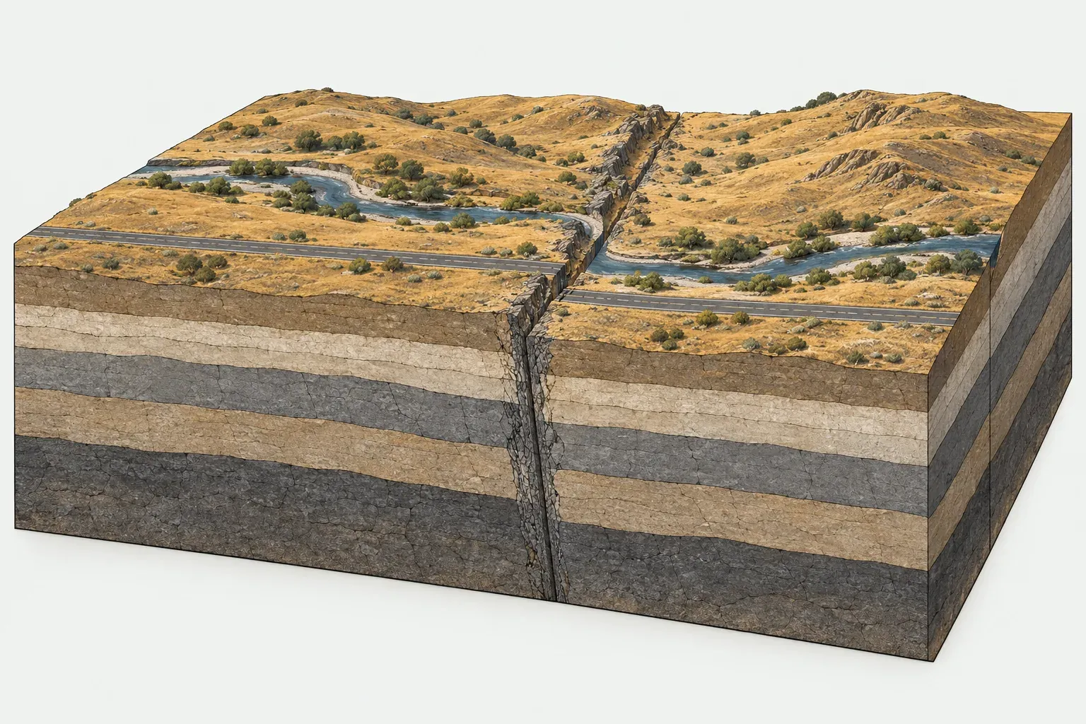
How transform boundaries work
A transform boundary is a fault along which two plates slide past each other. The motion is mostly horizontal, so geologists call these strike-slip faults. Looking across the fault, if the far side moves to the right the fault is right-lateral. If it moves to the left the fault is left-lateral.
Because the plates neither pull apart nor push together, crust is conserved at a transform boundary. That makes them different from the other two types: divergent boundaries make crust and convergent boundaries destroy it. Transform faults link those other boundaries together, passing motion from one ridge or trench to the next.
In the PB2002 model, transform faults make up about 74,100 km of plate boundary, more than a quarter of the total. About 47,900 km are oceanic transforms, with an average relative speed of about 4.1 cm per year. About 26,200 km are continental transforms, averaging about 2.5 cm per year.
Oceanic transforms and fracture zones
Most transform faults are on the ocean floor, where they cut mid-ocean ridges into segments. Ridges are broken into short pieces offset by transform faults, a pattern partly inherited from the uneven shape of the rift that first split the plates. The transforms line up with the direction in which the plates move. On our map these show up as dashed segments crossing the teal ridge lines at right angles, like the rungs of a ladder.
The Canadian geologist J. Tuzo Wilson worked out in 1965 how these faults move. Between two offset ridge segments, the plates slide in opposite directions. Beyond the ridge ends the fault scar continues as a fracture zone, a long linear valley or ridge on the seafloor. Along a fracture zone both sides belong to the same plate and move together, so it is no longer active. Some fracture zones, such as the Romanche Fracture Zone in the equatorial Atlantic, can be traced far beyond the ridge on seafloor maps.
Continental transforms
A few transform faults cut through continents. They are less common than oceanic ones but far more important to people, because cities sit right on top of them.
San Andreas Fault
The San Andreas Fault runs through California and marks part of the boundary between the Pacific Plate and the North American Plate. West of the fault, Los Angeles rides north-west on the Pacific Plate relative to San Francisco on the North American side. The fault links spreading centers in the Gulf of California in the south to the Mendocino triple junction in the north. It produced the 1906 San Francisco earthquake (M7.9), and many other faults in California and Nevada share the plate motion. Read more on the United States page.
Alpine Fault
The Alpine Fault runs along the western edge of the Southern Alps on the South Island of New Zealand, between the Pacific Plate and the Australian Plate. Unlike a pure transform, it also has some squeezing across it, and that component lifts the Southern Alps. It connects two subduction zones that dip in opposite directions, one to the north-east of the country and one to the south-west.
North Anatolian Fault
The North Anatolian Fault crosses northern Turkey between the Anatolian Plate and the Eurasian Plate. PB2002 gives about 2.4 cm per year of average relative motion along that boundary, nearly all of it classed as continental transform. Beginning in 1939, a series of large earthquakes ruptured the fault in a westward sequence, ending with the 1999 Izmit earthquake (M7.6) near Istanbul. Its sister fault in the south-east, the East Anatolian Fault, produced the M7.8 earthquake of February 2023 in Turkey and Syria.
Dead Sea Transform
The Dead Sea Transform runs north from the Gulf of Aqaba through the Dead Sea and the Jordan Valley into Lebanon. It separates the Arabian Plate from the African Plate and passes motion from the Red Sea rift north toward the collision zone in Turkey. Where the fault steps sideways, the crust has pulled apart into deep basins. The Dead Sea fills one of these basins, and its shore is the lowest dry land on Earth. See Israel and Jordan for local detail.
Caribbean examples
The north edge of the Caribbean Plate is mostly transform. PB2002 gives about 1.7 cm per year of average motion along its boundary with North America. Faults in this system caused the 1976 Guatemala earthquake (M7.5) and the 2010 Haiti earthquake (M7.0).
Why shallow quakes and few volcanoes
Shallow earthquakes
Rock only breaks in sudden earthquakes when it is cold and brittle. Along a transform fault that brittle layer is thin, generally the upper few tens of kilometers, and below it the rock deforms slowly without quakes. So almost all transform earthquakes are shallow.
Shallow earthquakes release their energy close to the surface, which is why continental transform quakes of magnitude 7 can be so damaging. On oceanic transforms the brittle layer is thinner still, and earthquakes there rarely exceed about magnitude 7. Because the seafloor moves sideways rather than up and down, they also seldom cause large tsunamis. Compare transform quakes with the much larger subduction quakes on the earthquake map.
Few volcanoes
Magma forms in only two common ways at plate boundaries. Rising mantle melts as pressure drops beneath a spreading ridge, and water from a sinking slab melts the mantle above a subduction zone. A transform fault does neither. Short volcanic stretches can appear where a transform pulls slightly apart, but long transform faults like the San Andreas have no volcanic chain. Compare that with the volcano map, where the volcanoes line up along ridges and subduction zones instead.
On our maps, transform boundaries appear as dashed lines. For the full set of boundary types and their lengths, see the plate boundaries overview.