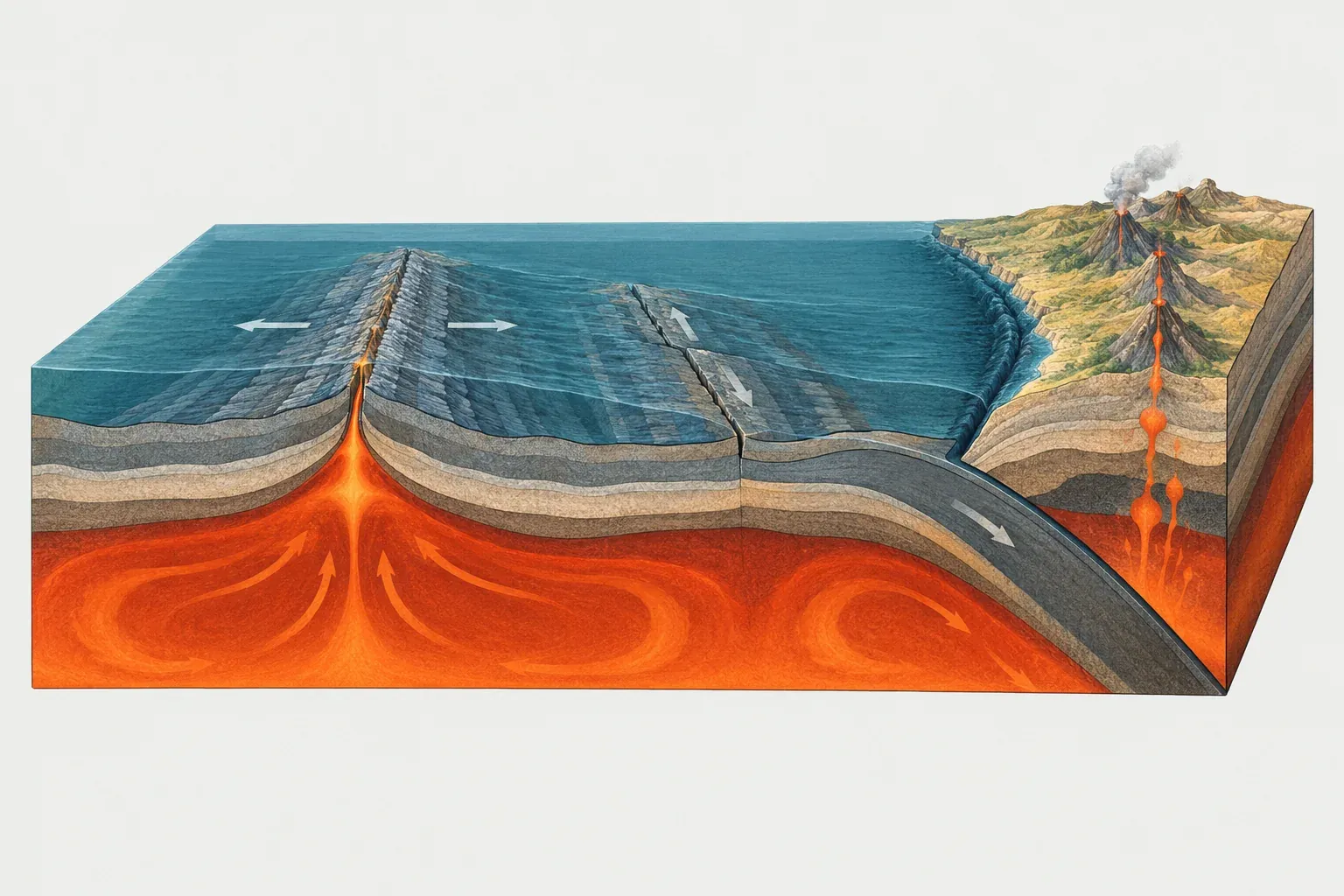
What a plate boundary is
Earth’s outer shell, the lithosphere, is broken into rigid pieces called tectonic plates. A plate boundary is the line or belt where two plates meet and move relative to each other. The interiors of plates are fairly quiet. The edges are where rock is created, destroyed, bent and broken.
Plates move only a few centimeters per year, but they never stop. Over thousands of years that motion builds up stress on faults at the boundary, and the stress is released in earthquakes. Over millions of years the same motion opens oceans, raises mountain ranges and feeds chains of volcanoes.
Geologists sort boundaries by the direction of relative motion. Two plates can move toward each other, away from each other, or past each other. Real boundaries often mix these, and a single boundary can change type along its length as it bends.
Where three plates meet, their boundaries join at a triple junction. In the Afar region of Ethiopia and Djibouti, the Red Sea, the Gulf of Aden and the East African Rift meet as three divergent arms. Off northern California, the Mendocino triple junction joins the San Andreas transform fault to the Cascadia subduction zone. Triple junctions move over time, so the boundaries attached to them grow, shrink and change type.
The three types of plate boundaries
Convergent boundaries
At a convergent boundary two plates move toward each other. If one of them carries dense oceanic lithosphere, it sinks beneath the other into the mantle in a process called subduction. Subduction builds deep ocean trenches, arcs of volcanoes and the largest earthquakes on Earth.
The Nazca Plate sinking beneath the South American Plate has built the Andes. The Pacific Plate sinking beneath Japan and the Aleutian Islands has built the volcanic arcs of the northern Pacific. When two continents meet, neither sinks easily, and the crust crumples into a collision belt. The Indian Plate pushing into the Eurasian Plate raised the Himalaya, including Mount Everest at 8,849 m.
Divergent boundaries
At a divergent boundary two plates pull apart. Hot mantle rock rises into the gap, partly melts and forms new oceanic crust. This is seafloor spreading, and it builds mid-ocean ridges, the longest mountain chains on the planet.
The Mid-Atlantic Ridge separates the North American Plate from the Eurasian Plate in the north, and the South American Plate from the African Plate in the south. On land, a divergent boundary starts as a rift valley. The East African Rift, where the Somali Plate is slowly separating from the African Plate, is the best known example. Iceland is a rare place where a mid-ocean ridge rises above sea level.
Transform boundaries
At a transform boundary two plates slide past each other horizontally. Crust is neither made nor destroyed, so these boundaries have few volcanoes, but they produce frequent shallow earthquakes.
Most transform faults are short offsets that connect segments of mid-ocean ridges. A few cut through continents and are famous for damaging earthquakes: the San Andreas Fault in California between the Pacific and North American plates, the Alpine Fault in New Zealand, and the North Anatolian Fault in Turkey, which bounds the Anatolian Plate.
Boundary classes in the PB2002 model
Our map uses PB2002, a global plate model published by Peter Bird in 2003. It defines 52 plates and splits every boundary into short steps. Each step gets one of seven classes based on its motion and on whether it lies in oceanic or continental lithosphere. The totals below come from the PB2002 boundary data, with average relative speeds weighted by length.
Convergent classes
- Subduction zone (SUB): about 51,500 km, averaging about 6.2 cm per year. This is the fastest class, which fits the idea that sinking slabs pull plates along.
- Oceanic convergent boundary (OCB): about 17,400 km, averaging about 1.8 cm per year. These are slow zones of convergence in ocean basins where a full subduction zone has not formed.
- Continental convergent boundary (CCB): about 23,000 km, averaging about 2.6 cm per year. This class covers collision belts such as the Himalaya and the Zagros Mountains of Iran.
Divergent classes
- Oceanic spreading ridge (OSR): about 67,300 km, averaging about 4.7 cm per year. This is the longest class of all.
- Continental rift boundary (CRB): about 27,500 km, averaging about 1.8 cm per year. Rifts that split continents open much more slowly than most ocean ridges.
Transform classes
- Oceanic transform fault (OTF): about 47,900 km, averaging about 4.1 cm per year.
- Continental transform fault (CTF): about 26,200 km, averaging about 2.5 cm per year.
Added together, PB2002 has about 260,800 km of plate boundary. Divergent steps make up about 36% of that length, convergent steps about 35% and transform steps about 28%. The numbers show something that a world map hides: transform faults are not rare oddities. They make up more than a quarter of all plate edges, mostly as short offsets along mid-ocean ridges.
Diffuse boundaries and orogens
Drawing a plate boundary as a single line works well in the oceans. Oceanic lithosphere is strong and uniform, so deformation stays in a narrow zone. Continental lithosphere is weaker and layered, and when it is squeezed or stretched the strain spreads across a wide region full of faults.
Bird marked the widest of these regions in PB2002 as orogens, zones where the 52-plate picture is a simplification. They include the Alps, the belt from Iran to Tibet, the Andes, western North America and the islands of the Philippines and Indonesia. Inside an orogen, small blocks move at slightly different speeds, and some of the microplates in PB2002, such as the Altiplano Plate under the central Andes, are attempts to capture that motion.
The ocean has diffuse boundaries too. PB2002 treats the Indian Plate and the Australian Plate as separate plates joined by a broad zone of deformation in the central Indian Ocean. Older textbooks merge them into a single Indo-Australian Plate. The 2012 Wharton Basin earthquake (M8.6) struck inside this zone, which shows that the seafloor there is breaking.
How to read the boundary colors on our map
The plate boundary lines on our maps follow the PB2002 step classes, grouped into the three main types:
- Orange-red lines are convergent boundaries: subduction zones, oceanic convergent zones and continental collision belts. Look for them along the edges of the Pacific Ocean and across southern Asia.
- Teal lines are divergent boundaries: mid-ocean ridges and continental rifts. The Mid-Atlantic Ridge runs as a teal line down the middle of the Atlantic.
- Dashed lines are transform boundaries. Along ocean ridges they appear as many short dashed offsets that cut the teal line into steps.
Click any plate to open its page, where you can see each of its neighbors, how long the shared boundary is and the average relative speed along it. For the earthquakes and volcanoes that line up along these boundaries, see the earthquake map, the volcano map and the Ring of Fire. Terms such as subduction, rift and transform fault are defined in the glossary.