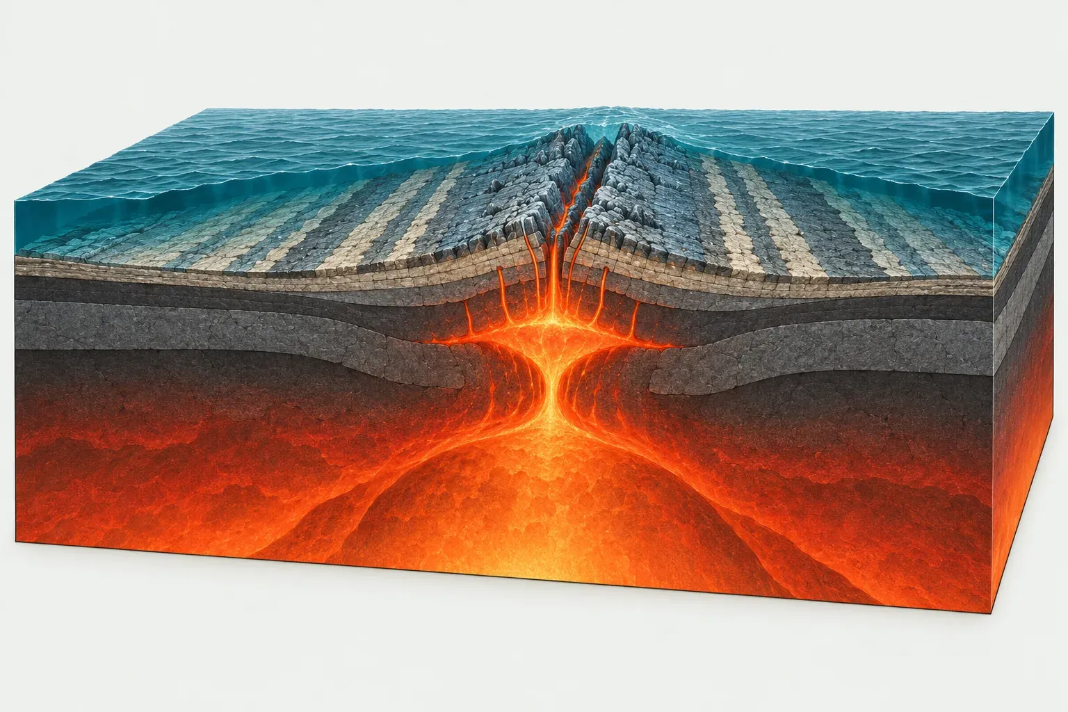
What a divergent boundary is
A divergent boundary forms where two plates move away from each other. As they separate, the mantle beneath them rises to fill the space. The rising rock is hot but solid. As it rises the pressure on it drops, and part of it melts. That melt rises further and cools into fresh crust, so divergent boundaries are where new lithosphere is made.
The PB2002 model contains about 94,800 km of divergent boundary, slightly more than either of the other two types. Most of it, about 67,300 km, is oceanic spreading ridge. The rest, about 27,500 km, is continental rift. The two classes move at very different speeds: spreading ridges average about 4.7 cm per year, while continental rifts average only about 1.8 cm per year.
Mid-ocean ridges and seafloor spreading
How seafloor spreading works
A mid-ocean ridge is a broad undersea mountain chain with a crack along its crest. Magma rises into that crack, erupts as pillow lavas on the seafloor and freezes into dikes and gabbro below. The new crust then moves away to each side as the plates keep separating, and fresh magma takes its place.
As the crust ages and moves away from the ridge it cools, becomes denser and sinks lower. That is why ridges stand high and old ocean floor lies deep. Seawater circulating through the hot rock near the crest feeds hydrothermal vents, including the black smokers first found on the seafloor in the late 1970s.
Magnetic stripes
When basalt cools at the ridge, iron minerals in it lock in the direction of Earth’s magnetic field. The field reverses every so often, so the ocean floor records a pattern of normal and reversed stripes running parallel to the ridge. The pattern on one side is a mirror image of the pattern on the other. This symmetry, recognized in the 1960s, was some of the strongest evidence for seafloor spreading and for plate tectonics as a whole.
Fast and slow ridges
Spreading rates vary more than tenfold between ridges, and the speed shapes the ridge itself. All rates below are full rates from PB2002, meaning how fast the two plates separate.
The East Pacific Rise is the fastest. Along the boundary between the Pacific Plate and the Nazca Plate, PB2002 gives an average of about 14 cm per year, and up to about 15 cm per year in places. Between the Pacific and the Cocos Plate the average is about 10 cm per year. Fast ridges are smooth, broad swells with no deep valley at the crest, because the magma supply is steady.
The Mid-Atlantic Ridge is slow. Between the North American Plate and the Eurasian Plate the average is about 1.5 cm per year, and between the South American Plate and the African Plate it is about 3.2 cm per year. The Atlantic Ocean as a whole widens by about 2.5 cm per year. Slow ridges have a rugged crest with a deep central rift valley, because the crust is stretched and faulted between pulses of magma.
The Indian Ocean has examples of both. The ridge between the Australian Plate and the Antarctic Plate averages about 6.8 cm per year, while the ridge between the Somali Plate and Antarctica averages only about 1.2 cm per year.
Iceland: a ridge on dry land
Iceland is where the Mid-Atlantic Ridge rises above the sea. A mantle hotspot under the island adds extra magma, so the crust there is much thicker than normal ocean crust. In PB2002, about 56% of Iceland lies on the North American Plate and about 44% on the Eurasian Plate.
The boundary crosses the island as a belt of fissures, faults and volcanoes rather than a single crack. At Thingvellir, visitors can walk through a rift valley between fault walls. The Laki fissure eruption of 1783 and the repeated fissure eruptions on the Reykjanes Peninsula since 2021 show what divergent volcanism looks like: long cracks that pour out runny basalt lava rather than tall cones.
Continental rifts: how oceans are born
The East African Rift
When a continent begins to split, it first stretches and thins. Blocks of crust drop down between faults to form a rift valley, and magma reaches the surface through the thinned crust. The East African Rift runs from the Afar region of Ethiopia south through Kenya and Tanzania. It marks the boundary between the African Plate (also called the Nubian Plate) and the Somali Plate.
The rift is very slow. PB2002 gives an average of only about 0.3 cm per year along the Somali/African boundary. Some geologists also divide East Africa into further small blocks, and the Somali Plate itself is one of the PB2002 plates still debated. Even so, the rift has deep lakes, active volcanoes and frequent earthquakes, and Mount Kilimanjaro, at 5,895 m, is a volcano that grew close to it.
The Red Sea and Gulf of Aden
The Red Sea shows the next stage. There, the Arabian Plate has pulled far enough away from Africa that the rift has flooded and new oceanic crust has begun to form along its center. PB2002 gives about 1.4 cm per year of average motion along the Arabian/African boundary. In the Gulf of Aden, between Arabia and the Somali Plate, the rift has become a true spreading ridge opening at about 2.4 cm per year.
The Red Sea, the Gulf of Aden and the East African Rift meet in Afar, in Ethiopia and Djibouti. This is a triple junction, a point where three plates meet, and it is one of the few places where you can see all the stages of ocean birth side by side.
Rifts that failed
Not every rift becomes an ocean. Some stop stretching and are left as buried basins. The Atlantic itself began as a set of rifts when Pangaea broke apart, and some of those rifts stalled while others opened into the ocean we know today.
Divergent boundaries on our map
Divergent boundaries appear as teal lines on our maps. In the oceans they are broken into steps by short dashed transform faults, which you can read about on the transform boundaries page. Compare them with convergent boundaries, or return to the overview of all plate boundaries. Words like rift, ridge and triple junction are explained in the glossary.