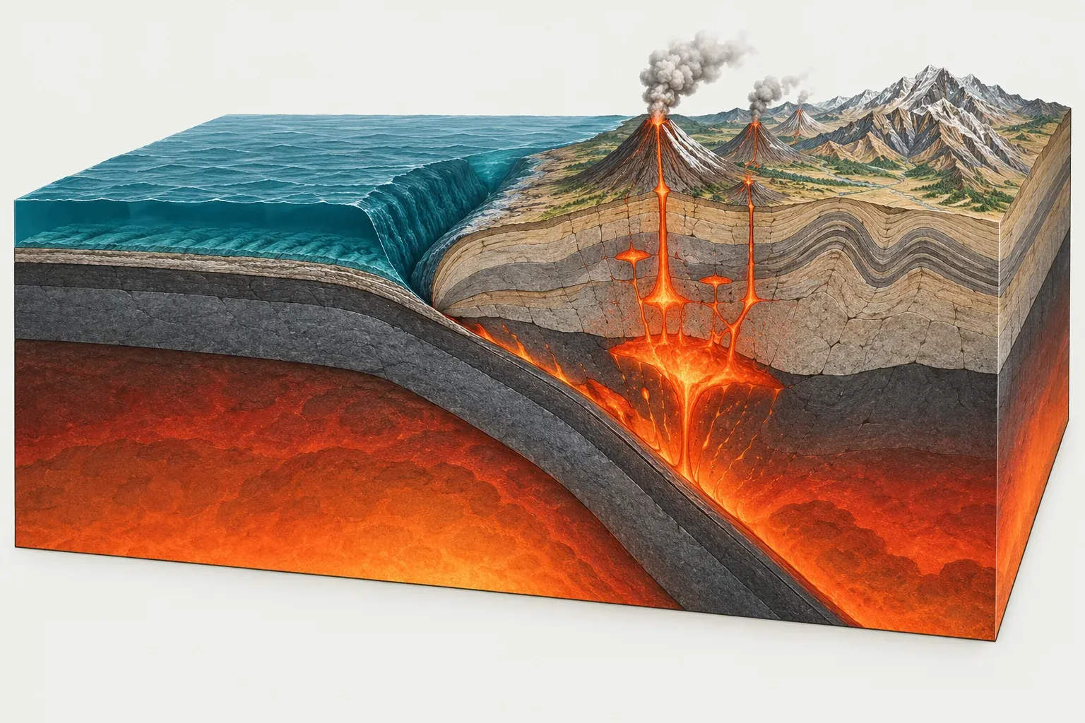
What a convergent boundary is
A convergent boundary forms where two tectonic plates move toward each other. Because Earth is not growing, the crust made at mid-ocean ridges has to be used up somewhere, and convergent boundaries are where that happens. In the PB2002 model about 91,900 km of plate boundary is convergent, roughly a third of the total.
What happens at the boundary depends on what kind of lithosphere each plate carries at its edge. Oceanic lithosphere is dense and sinks readily once it is old and cold. Continental lithosphere is thick and buoyant, and it resists sinking. That gives three basic combinations.
The three types of convergence
Oceanic-oceanic: island arcs
When two oceanic plates converge, the older and denser one sinks beneath the other. The sinking plate bends down at a deep ocean trench. As it descends to around 100 km, it releases water into the hot mantle above it. The water lowers the melting point of that mantle rock, magma rises, and a curved chain of volcanic islands grows on the overriding plate.
The Mariana Trench, where the Pacific Plate sinks beneath the Mariana Plate, holds the deepest point in the oceans, nearly 11 km below sea level. PB2002 gives about 6.3 cm per year of convergence along that boundary. Farther south, the Pacific Plate dives beneath the Tonga Plate at the Tonga Trench at up to about 26 cm per year, the fastest plate motion in the whole model. The Aleutian Islands of Alaska and the Lesser Antilles in the Caribbean are other island arcs.
Oceanic-continental: volcanic mountain ranges
When an oceanic plate meets a continent, the oceanic plate always subducts. The trench forms just offshore, and the volcanic arc grows on the continent itself, building a range of high volcanic peaks.
The Andes are the classic case. The Nazca Plate sinks beneath the South American Plate along about 4,300 km of subduction zone, converging at an average of about 7.8 cm per year in PB2002. The same process formed the Cascade Range of the northwestern United States, where the small Juan de Fuca Plate subducts beneath the North American Plate at about 4.0 cm per year. In Central America, the Cocos Plate sinks beneath North America and the Caribbean Plate, feeding the volcanoes of Mexico, Guatemala and Nicaragua.
Continental-continental: collision belts
When the ocean between two continents has been fully subducted, the continents themselves meet. Neither sinks far, so the crust stacks up, folds and thickens. The result is a wide belt of high mountains and plateaus with frequent earthquakes but few volcanoes.
The Indian Plate has been colliding with the Eurasian Plate for tens of millions of years. PB2002 gives an average convergence of about 4.7 cm per year across their boundary, most of it classed as continental collision. The collision raised the Himalaya and the Tibetan Plateau, and Mount Everest, at 8,849 m, is the highest point on Earth. To the west, the Arabian Plate pushes into Eurasia at about 3.5 cm per year, building the Zagros Mountains of Iran. The Alps formed in a similar way as Africa and smaller plates closed on Europe.
Features of a subduction zone
Trenches and accretionary wedges
A trench marks the line where the subducting plate bends down. Sediment scraped off the sinking plate can pile up against the overriding plate as an accretionary wedge, a growing stack of folded mud and sand. Where little sediment arrives, the trench stays deep and steep.
Volcanic arcs
Arc volcanoes sit a consistent distance behind the trench, above the point where the slab reaches the depth at which it gives off water. Their magma is rich in silica and gas, so they tend to erupt explosively. Mount St. Helens in 1980 and Pinatubo in the Philippines in 1991 were both arc volcanoes. See the volcano map to compare arcs around the world.
Back-arc basins
Behind some volcanic arcs, the overriding plate is stretched rather than squeezed. When the sinking slab rolls back toward the ocean, the plate above it can split behind the arc and open a small spreading basin, called a back-arc basin. The Mariana Trough is the standard example. PB2002 treats the crust east of it as the separate Mariana Plate, which pulls away from the Philippine Sea Plate at an average of about 3.1 cm per year. The Sea of Japan opened in a similar way millions of years ago, carrying the Japanese islands away from mainland Asia.
Benioff zones and deep earthquakes
Earthquakes inside a subducting slab trace its path into the mantle. Plotted in cross-section, they form a dipping band called a Benioff zone that can reach about 700 km deep. The 2013 Sea of Okhotsk earthquake (M8.3) struck at a depth of 598 km inside the Pacific slab beneath the Okhotsk Plate, one of the largest deep earthquakes on record.
Megathrust earthquakes
The shallow contact between the two plates is a giant thrust fault, the megathrust. Friction locks it for decades or centuries while the plates keep moving, then it can slip by tens of meters in a few minutes. These are the largest earthquakes on Earth, and because they lift or drop the seafloor, they often cause tsunamis.
Every earthquake of magnitude 9 or above since 1900 was a megathrust event: Chile in 1960 (M9.5), Alaska in 1964 (M9.2), Sumatra in 2004 (M9.1), Japan in 2011 (M9.1) and Kamchatka in 1952 (M9.0). The 2011 Tohoku earthquake ruptured the Japan Trench, where PB2002 gives the Pacific Plate about 8.7 cm per year of convergence against the Okhotsk Plate. Browse more on the earthquake map.
Convergent boundaries on our map
Convergent boundaries appear as orange-red lines on our maps. Most of them ring the Pacific Ocean, forming the Ring of Fire, and a second belt runs from the Mediterranean through Iran and the Himalaya to Indonesia. To compare them with the other types, see divergent boundaries, transform boundaries and the overview of all plate boundaries.